
Using a drone to create an accurate farm map | The Land | NSW
Drones and supporting software have developed rapidly in recent years and it is now economically viable and practical to consider using a drone to survey your property and a supporting software package to develop farm maps showing boundaries, paddock, soils and infrastructure.
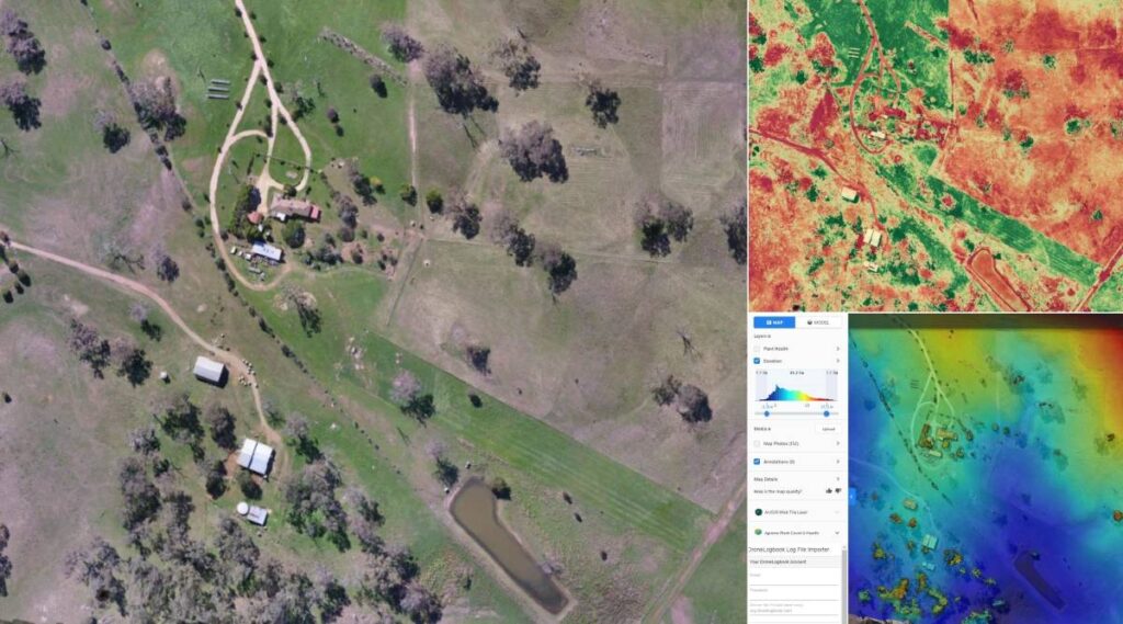
Using a drone survey method can be particularly useful for a smaller and more intensively managed property where the resolution of satellite imagery used in a standard Google map is not adequate to see all details.https://23c6001adc44c4e1323c160194bb104a.safeframe.googlesyndication.com/safeframe/1-0-38/html/container.html
Think carefully before proceeding with a drone survey as you will need to be comfortable and competent using the lasted technology.
If you are not comfortable with using a drone and tablet-based software you should avoid this, but if you already own or have access to a suitable drone, this is a very attractive option.
A suitable drone should cost around $2000 which will include additional battery and spare propellors.
You will need a tablet, an installed app and:
- A drone with mission planning capability. This means that the drone can be controlled and carry out the survey controlled entirely by the software;
- The drone needs to be equipped with a high quality RGB (red/green/blue) camera and/or the option to fit a Normalised Differential Vegetation Index (NDVI) - or similar - camera; and
- The drone needs compatibility with third party software.
A suitable drone and supporting software can carry out a field scale survey of up to 50ha in one to two hours.
The survey process is rapid and can be carried out on an ongoing basis to record changes on the farm.https://23c6001adc44c4e1323c160194bb104a.safeframe.googlesyndication.com/safeframe/1-0-38/html/container.html
Consider the use and required resolution of the map.
Higher resolution requires a lower survey height and more passes to cover the area, so will take additional time.
Attach the tablet with the supporting software app to the drone controller, enter the field or property boundaries into the software and specify the resolution required.
Higher resolution with require more flight paths and be at a lower altitude.
The disadvantage of higher resolution is that it will generate a much larger file.
Once you have entered the field boundaries, the software will calculate the flight path and the drone will carry out the survey in an automated mode.
Operating within the Civil Aviation Safety Authority (CASA) rules, it is essential that the drone remain in line of sight of the operator.https://23c6001adc44c4e1323c160194bb104a.safeframe.googlesyndication.com/safeframe/1-0-38/html/container.html
When the drone has completed the pre-programmed survey, it will return to the starting point with all the survey data stored on the tablet and on an onboard Micro SD Card ready for transfer to the device for processing.
Once the data has been processed, it will display a digital image on the tablet or computer.
Software packages have numerous options for enhancement and analysis of specific issues.
Once you have the base map you can add layers to show infrastructure, vegetation, soil types, and land classification.
The advantage of a map developed on this platform is that it will be current, and the same survey can be flown again to update the map to show changes on the farm.
If you do not want to invest in a drone or do not feel confident to carry out the survey yourself, it is possible to get a survey done commercially by a contractor.
Remember, a quality processed map is better than a cheap poor resolution map.
Tocal College offers a training course called Drones in Agriculture which will help you become familiar with the basic operation of a drone and the use of supporting software.
This course will also familiarise you with the rules and regulations governing drone usage and highlight the need to identify if your property is in restricted airspace.
If you are in restricted airspace you may need other approvals before you fly a drone.
- You can find details of the course at: Drones for livestock businesses (www.tocal.nsw.edu.au).
- Original Article