
The Bralca team is excited to be attending the 22nd NSW Weeds conference this week ‘weeds gone wild’.[i] They will be showcasing some of the practical application of drones in weed treatment. That said, drones offer so much more when considering landscape scale weed management control. They are used to provide sound data about the where, what, and how many of weed infestations and are used as a follow up to assess the effectiveness of the weed control measures undertaken.
As drones are quickly becoming part of any land managers’ toolkit, increasing possibilities are presenting themselves. More and more this is backed by research so throughout this post we have provided links to a few articles for you.
How might this work?
1. Know where you are working.
Weed control strategies are impacted heavily by the terrain and landscape you are working in. Accessibility, runoff risk and sensitive environments are all considerations. A drone map provides you with a visual of the site, the elevation and a ‘birds eye view’ of the surrounding landscape to assist you to consider the most appropriate strategy for the weed location (and spread). Even little things like knowing the distance from potable water sources, amenities and roadways can be very helpful when pulling your planned approach together. There is a number of excellent software solutions (eg. Drone deploy) readily available now that can create these types of maps for you very quickly.
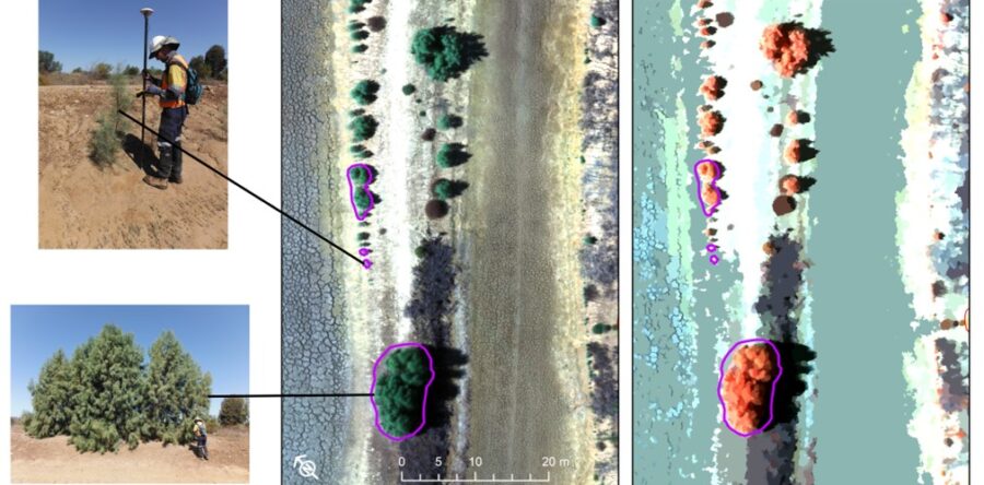
2. Identifying the type (or types) of weed you are controlling
The beauty of drones is that you can very quickly and cost effectively capture information about weeds. Drone imagery allows spatial resolutions that are fine enough to differentiate vegetation, often to the level of individual trees or shrubs. Using computational algorithms that detect spectral and structural differences across images, it is possible to distinguish different species of vegetation. This allows the identification of weeds. When you know the variety of weed, or weeds, and their stage of growth, you can start to decide on control type and application rate. This can make a big difference of approach between spot spraying on foot, aerial spraying and broadacre application.
Check out this case study undertaken by the Sustainable Minerals Institute.[ii]
3. Knowing the stage of growth
Living in a variable climate means the ideal time for weed control programs varies greatly. Having information that allows you to plan the timing of your control can play a significant role in your effectiveness. Spraying target plants in a non growing period not only wastes chemical, it also can further increase chemical resistance. Too early or too late and you may be wasting your time.
4. Understand the density of the populations
Once you know the location, type and stage of growth, understanding the density means you can now calculate the area to be controlled. When spraying is part of your control, this can vastly impact the planning total area to be treated, spray rate calculations helping to save money[iii] and prevent unwanted environmental damage. Tony Single talks further about his approach in his GRDC article.[iv]
5. Keeping aerial surveys safer and more accessible to land managers
Traditional aerial surveys are both expensive and dangerous. Drones operations come in at under ½ the cost of traditional methods and allow pilots to use their skills whilst staying safely on the ground. A big plus in our world! Georeferenced data from the drone creates research quality digital twin maps to assist with planning and reporting.
6. Caring for the Environment
On top of better information meaning, you can adjust your control to the environment, the collection of information can also be done with minimal impact in sensitive environmental areas such as water bird nesting areas. The Griffin pro blue edition used by Bralca, is inaudible at 120m, the fauna can't hear it and neither can grazing stock so you can be assured that noise pollution is no longer a concern.
7. Know if your strategy has worked.
One important step in any weed control strategy is checking to see that your initial selected control is working. With it now being possible and cost effective to remap an area at selected intervals after a control has been applied you can continue to update and adjust your strategy across the years. Being able to report on this for those using any third-party funds is also critically important.
How can Bralca play a part?
Bralca has highly specialised military spec drones that can take accurate heat maps and images to assist with state run, coordinated efforts. Bralca has partnered with global developers and manufacturers to access subaudible surveillance drones providing live feeds to team commanders that meet CASA requirements to assist with landscape weed control. Whilst this assists in both mapping and control operations, it is just part of the solution.
NSW covers 801,600 square kilometres so we believe the greatest impact is supporting the land managers across that expanse to build their own skills and knowledge around the use of drones in their enterprise. The fully accredited Drone training under Agskilled 2.0[v] gives land managers the skills to monitor their own lands and connect into coordinated programs with more accurate and timely data than centralised entities trying to achieve this alone. We believe this puts the knowledge and power into the wide variety of land managers across our landscape and recognise they have an invested interest in getting this right. By working together and coordinating local, regional and state based activities, drones can play a major part in supporting landscape scale weed management strategies[1].
Bralca.com: creating choice through knowledge
By: Fiona Watts
[i] 22nd NSW Weeds Conference Website: https://www.nswweedsconf.org.au/program-field-trips/
[ii] Sustainable Minerals Institute paper published on the University of Queensland website https://smi.uq.edu.au/cmlr-research/ecosystem-assessment-restoration-resilience/project/detection-weed-species-high-resolution-drone-imagery-object-based-image-analysis#:~:text=Using%20computational%20algorithms%20that%20detect,remove%20these%20threats%20to%20rehabilitation.
[iii] Ben Single reported a saving of $13.40 per ha in the treatment of milk thistle on a broadacre application. https://grdc.com.au/resources-and-publications/grdc-update-papers/tab-content/grdc-update-papers/2023/02/weed-mapping-using-drones-for-targeted-weed-spraying#:~:text=Drone%2Dbased%20weed%20mapping%20allows,(radius)%20around%20the%20weeds.
[iv] Drone weed mapping for spot spraying: Know what’s there before you spray. https://grdc.com.au/resources-and-publications/grdc-update-papers/tab-content/grdc-update-papers/2021/08/drone-weed-mapping-for-spot-spraying
[v] Drones in Agriculture and Farm mapping and data collection are both available through Tocal College. Pastoralists are now eligible in the next round commencing soon.